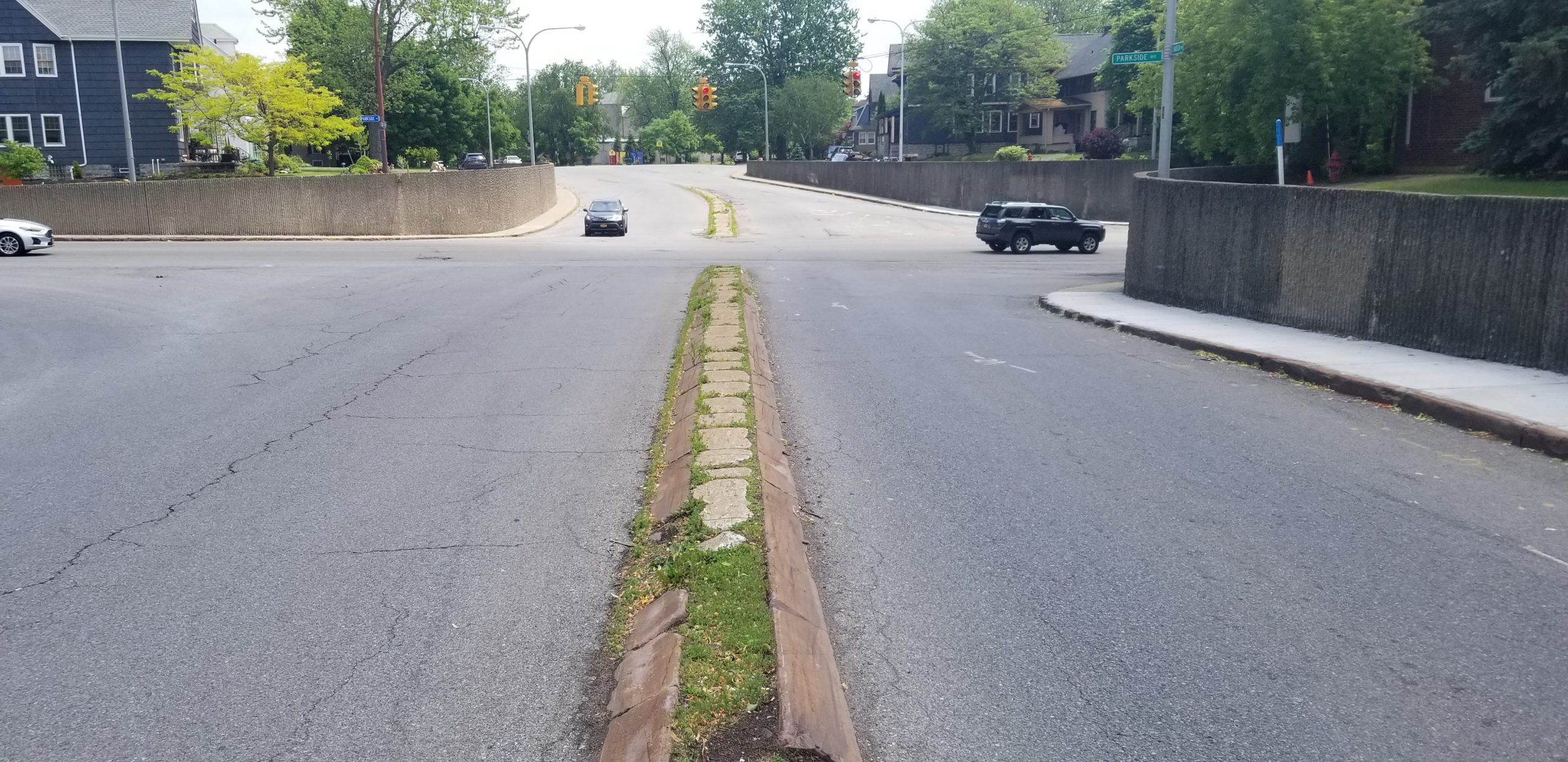
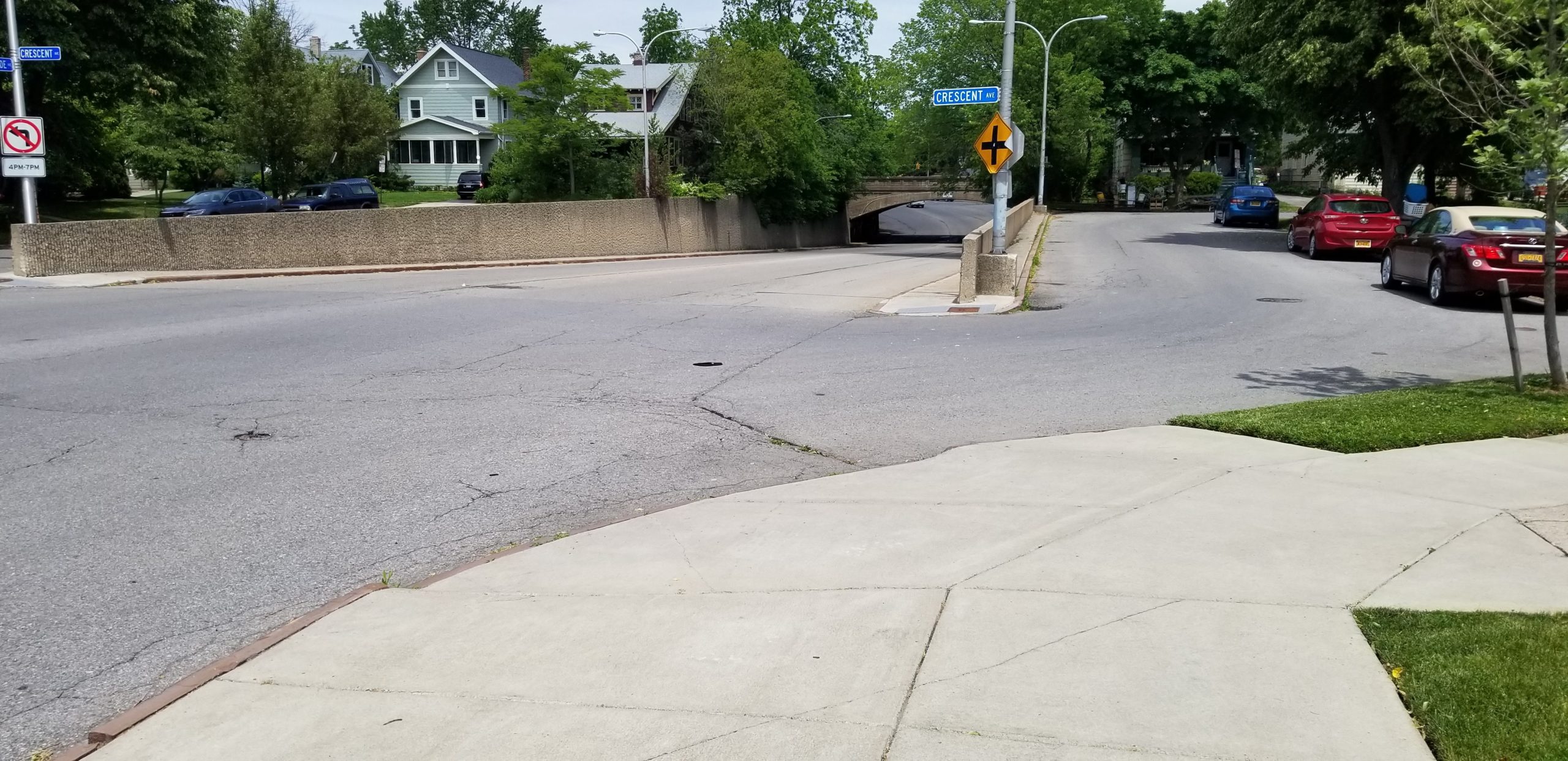
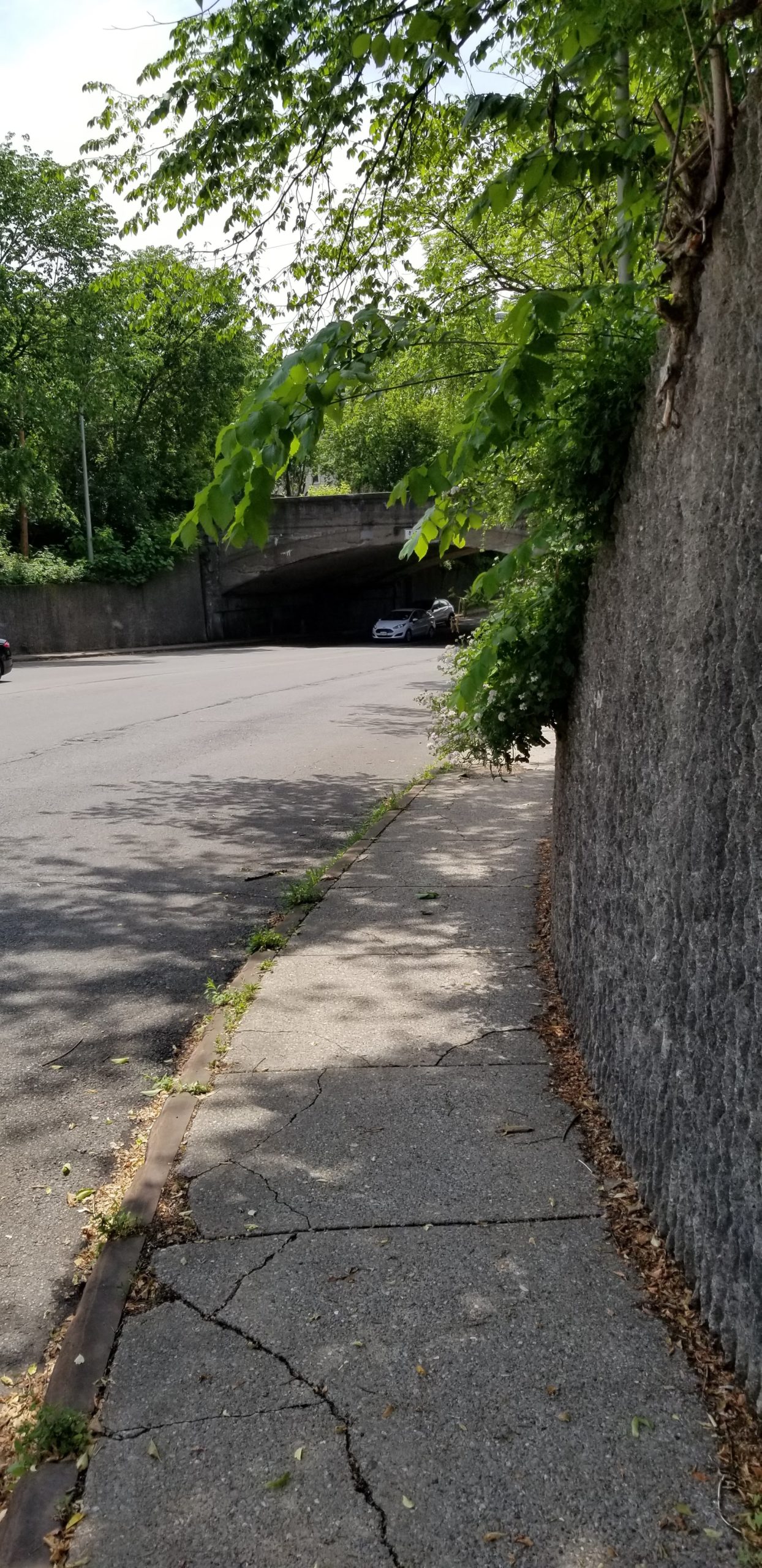
The project will address the existing lack of ADA accessibility and excessively wide drive lanes at the intersection of Parkside and Linden to provide safer continuous passage for pedestrians to the adjacent intersections of Depew Avenue and Crescent Avenue and the substandard sidewalks along Parkside Avenue as it passes underneath the Beltway-Subdivision railroad bridge.
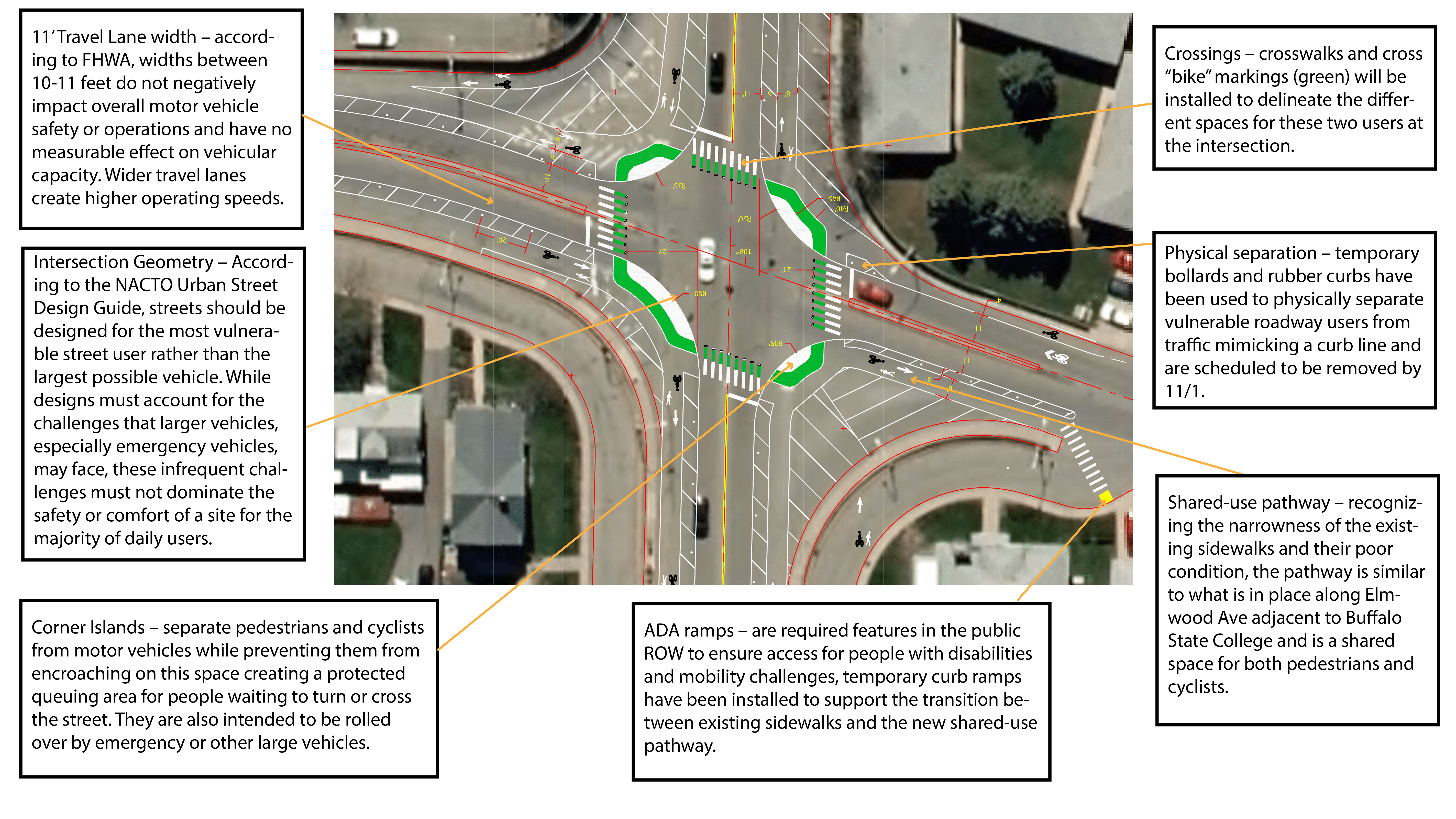
The project will include extensive pavement markings that will narrow the vehicular travel lanes, add buffered and protected multi-use pathways and temporary ADA curb ramps connecting to existing sidewalks, protections at the intersection for bicycles, crosswalks and stop lines.
GObike’s contract with the GBNRTC for providing assistance implementing the Bike Buffalo Niagara master plan and our expanding role in leading walkability advocacy throughout the region will help strengthen our choices in human powered mobility.
This will be the first “protected intersection” in Western New York! Not a roundabout, a protected intersection uses infrastructure to separate cars and trucks from children and adults walking, rolling, and riding through this intersection – which of course was the main purpose of this work in the first place, to provide much needed protection to people outside of cars.
COMPLETE REPORT
Please read the report.
Everything is included.
The overall % of speeding vehicles dropped from 62% to 30%. Pedestrian and bicycle activity increased by 130% and 141% respectively.
You’ve got questions or assumptions? We’ve got answers and data.
City of San Luis Obispo, California
Long Beach, California
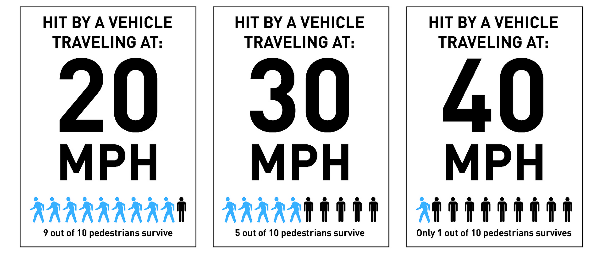
The effective lane widths now indicate the safest travel path for vehicles utilizing design to reduce vehicle speed. This is important because as vehicle speeds increase, the risk of serious injury or fatality for a pedestrian also increases (AARP Impact Speed and a Pedestrian’s Risk of Severe Injury or Death). Parkside Avenue is a two lane street and the lane widths now reflect that function.
The project uses temporary products including paint, bollards and rubber curbs to inexpensively reorient the intersection. As part of the public engagement process, it will allow people to experience the new design in real time and collect pre and post data to determine how it functions for all roadway users to inform the city’s process before a long term capital investment is made. It is scheduled to be in place through 11/1.
This demonstration project satisfies the Americans with Disabilities Act (ADA) requirements within the public right-of-way (ROW) while providing safer and protected facilities for pedestrians and bicyclists, improving vehicle safety and complying with the City of Buffalo’s Complete Streets policy.
ADA refers to the Americans with Disabilities Act. The Department of Justice’s 2010 ruling requires curb ramps at newly constructed or altered streets, highways, or street-level pedestrian walkways. Every yellow dot in the large map above depicts a new accessible crossing for people using chairs, strollers, or with other disabilities that require a ramp.
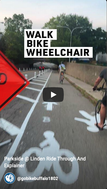
Improving access for walking and using a wheelchair was the initial charge of this entire project. After granting access, the drive lane redesigns work to slow cars down and make crossing the intersection safer.
Drainage under the bridge is outside of the scope of work by GObike Buffalo. GObike team members and volunteers have taken actions to clear surface debris from drainage structures during the project installation.
It continues to be the city’s responsibility to clear snow from the street, this function remains unchanged. The temporary demonstration project is not scheduled to be in place beyond 11/1 and will not impact this.
The bollards and rubber curbing have been installed to accommodate oversized vehicles that violate existing route restrictions.
The city has adjusted the signal timing and excessive queuing of vehicles is not anticipated. Through the first two weeks of implementation, no seriously stalled traffic has been reported.
As a walkability project, this intersection was widely recognized as unsafe for people and included sidewalk facilities that are not in compliance with ADA requirements. Between 2017 and 2021, there were 18 crashes at this intersection, and eight of those resulted in injury to drivers and pedestrians. Prior to design, GObike Buffalo conducted traffic counts for all travel modes and speed studies to determine baseline measures. 750 door hangers were also distributed throughout the neighborhood to understand resident concerns about the intersection.
Check out that data here: Parkside Linden Speed Study Spring 2023 Parkside Linden, Pre-Installation All Vehicle Traffic Counts Parkside Linden Peak Hour Data
The ratio of speeding vehicles, the maximum recorded speed, the 85th percentile speed, the change in bicycle and pedestrian activity will be the primary quantitative data evaluated. Public survey responses will be recorded for qualitative assessment.
A $15,000 grant from the Erie County Department of Health (through the National Association of Chronic Disease Directors (NACDD), in collaboration with the Centers for Disease Control and Prevention’s (CDC) National Center for Chronic Disease Prevention and Health Promotion (NCCDPHP) Division of Nutrition, Physical Activity, and Obesity (DNPAO) and the New York State Department of Health (NYSDOH) Physical Activity and Nutrition (SPAN) Program), and an $18,000 grant from the Delaware District Council Member Joel Feroleto.
The City of Buffalo has stated they are preparing for a $3 million capital improvement project for the intersection. This project helps fulfill community engagement requirements for that anticipated project which will include additional opportunities for the public to weigh in on the final design.
Yes, and we have a concept drafted which can be viewed here (Linked here). While this can be an effective treatment for the intersection, with existing infrastructure in place, we were not able to implement a demonstration project to test it.
Between 2017 and 2021, there were 18 crashes at this intersection, and eight of those resulted in injury to drivers and pedestrians.
Here are some of the quotes we received from those who took our survey in January 2023 (after nearly 700 door hangers went out to the closest 700 homes):
“I have always been concerned about this intersection. There is not a safe place to cross the street in any direction. I find it unsafe to walk anywhere around this corner and avoid it. I would love to see something done to improve this corner. It makes no sense as it is. Thank you for working to make it better.”
“I grew up in this neighborhood. All of these intersections have been horrible to walk, run or drive in. It’s only getting worse. It is not a good location for anyone. Something must be done soon.”
“I feel safe as a driver because I am a defensive driver, but for a walker in the area I feel it is very dangerous. I walk a lot in the warmer months and often avoid this intersection out of fear.”
“I bike and lead bike tours for Explore Buffalo in Parkside and Central Parkside Neighborhoods from April through October. Very hard to cross streets at Parkside and Linden and also Amherst and Parkside Ave. please also look at the intersection of Parkside and Amherst St dangerous for pedestrians and cyclists to cross also.”
“For what is such a densely populated area, a neighborhood with many children, walkers, bicyclists, etc. this is perhaps the most irresponsible and poorest or urban plans within the city.”
“Every time I walk or bike through the narrow corridor on Parkside under or near the concrete railroad bridge I feel anxiety. The sidewalk is obviously too narrow and because of the concrete walls one has limited options to avoid a vehicle that veered toward one while either walking or biking. I think redesigning this dangerous bottleneck is a great idea! Thanks”
“I have lived in this neighborhood for 12+ years and walk and run daily. The intersection of Parkside and linden I avoid and find alternative ways to get through to Hertel because it is not accessible!”
“I have teen children. I encourage them to take Colvin and avoid the Parkside Linden intersection because it is so dangerous. I am an avid walker and also avoid that intersection. It is the closest major intersection, nearest to my home.”
“I live on Tillinghast. My kids (9,7,6) have friends on Depew and Woodbridge. I do not know at which age I’d be comfortable with them crossing at Linden and Parkside given the current conditions. I would support restructuring the intersection to better the neighborhood.”
“I made the decision to no longer ride my bike in this area because of this intersection. It is very dangerous for bike riders and walkers and I am happy it is being changed. Clear cross walks, bike lanes, signs & cross walk lights would help this intersection become safer for our neighborhood.”
“I use an electric scouter during the summer months and travel this intersection often. Frankly is scary and dangerous”
“I walk a lot in the area especially early morning with my 3 dogs. I always felt there needed to be a better way for overall safety and design in that specific location. I also bike to work during spring/summer/fall and it can get tricky around that area. I welcome a new approach for all modes of transportation including foot traffic.”
“I walk in our neighborhood with my dogs and plan to once my first baby arrives this spring. I have been worried about crossing Parkside to get to Depew with a stroller. The proposed changes will help our community immensely!”
“I would certainly drive a lot less if I felt it was safe to navigate this intersection as a walker or on bike to get to Hertel.”
“I would like to bike, but crossing Parkside is generally very terrible and absolutely limits my mobility as a biker. Walking along and across is very difficult as well. I personally identified the Parkside Linden crossing to Erie County and am very thankful that you all are going to address it. Keep up the good work.”
Existing Conditions
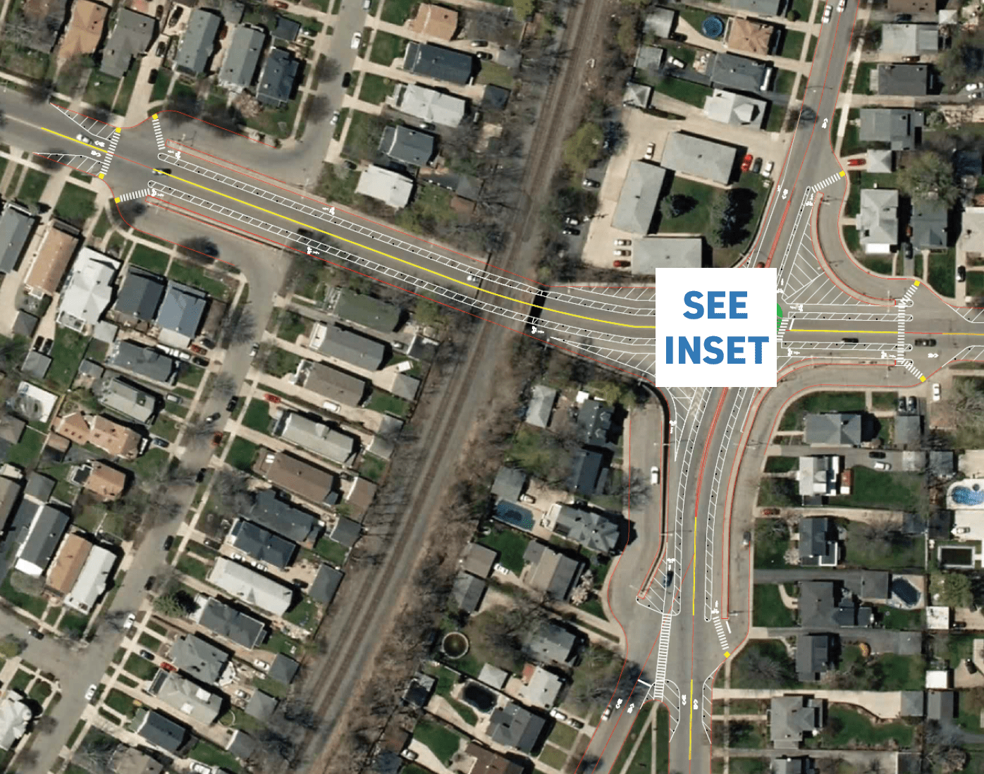
Proposed Scope of Work
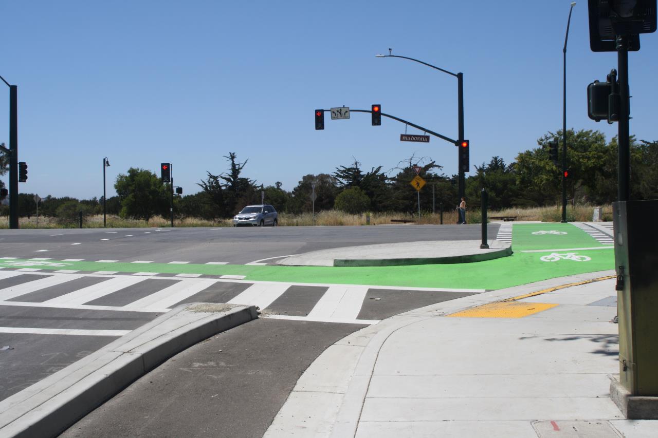
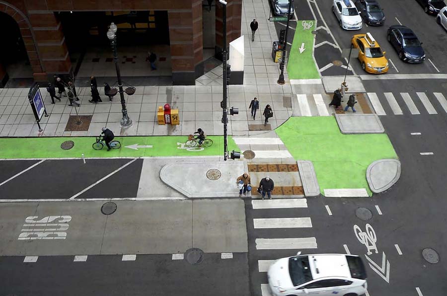
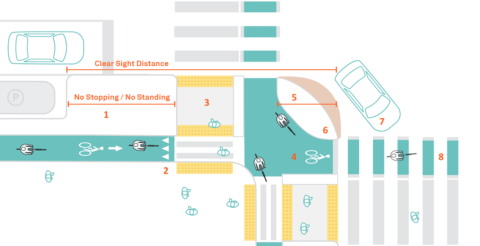
What is a protected intersection?
Protected intersections have been implemented across North America as cities have expanded their protected bikeway networks. Also known as setback or offset intersections, this design keeps bicycles physically separate from motor vehicles up until the intersection, providing a high degree of comfort and safety for people of all ages and abilities.This design can reduce the likelihood of highspeed vehicle turns, improve sightlines, and dramatically reduce the distance and time during which people on bikes are exposed to conflicts. For example, in San Francisco, a protected intersection design resulted in 98% of drivers yielding to people on bikes, and 100% yielding to people walking.A study in New York found that protected intersections had fewer vehicle-bike conflicts than even a dedicated turn lane with a dedicated bike signal phase. Learn more from the National Association of City Transportation Officials (NACTO)
Description
At protected intersections, the bikeway is set back from the parallel motor vehicle traffic. Unlike at conventional bike intersections, people biking are not forced to merge into mixed traffic. Instead, they are given a dedicated path through the intersection, and have the right of way over turning motor vehicles.
The setback between the motor vehicle lane and the bikeway makes people on bikes more easily visible to turning drivers than in a conventional intersection.
Corner islands anchor the design, extending the protected bike lane’s separation as far into the intersection as possible and tightening the corner’s turn radius. They create a bike queue area after the crosswalk, the natural place for people on bikes to wait.
The setback creates a waiting zone for turning cars, where drivers can yield to bikes after starting to turn but before crossing the path of oncoming bicycles. If it is large enough, this area lets drivers wait while through-traffic passes them, relieving pressure to turn too quickly.
Protected intersections also provide shorter, safer crossings for people walking. With low-speed vehicle turns and room for accessible pedestrian islands, people on foot and using personal mobility devices get many of the benefits of curb extensions.
Protected intersections create shorter, simpler crossings, more predictable movements, and better visibility between people on bikes and people driving. As a result, the intersection is more comfortable and safer for people using the bikeway and the crosswalk.
1. No Stopping / No Standing Zone Motor vehicle parking and stopping are prohibited on the approach to the intersection.
2. Bike Yield Line (optional)
3. Pedestrian Islands Islands reduce crossing distances and improve visibility by keeping the intersection clear. Wider islands support high volumes of people walking and biking, raising the capacity of the intersection. In some cases, islands can reduce the signal time needed for pedestrians.
4. Bike Queue Area
People biking can wait ahead of the crosswalk for a green signal or a gap in traffic. This shortens crossing distances, and accommodates the natural positioning of people biking. Bike detection optional.
5. Bikeway Setback
The setback determines how much room will be available for drivers to wait and yield, and the angle at which they cross the bikeway. Larger setbacks provide better visibility and give people bicycling more time to notice and react to turning vehicles.
6. Corner Island
A corner island separates bikes from motor vehicles, prevents motor vehicles from encroaching on the bikeway, and creates a protected queuing area for people on bikes waiting to turn.
7. Motorist Waiting Zone
The space between the motor vehicle lane and the crossbike provides a place for motor vehicle drivers to wait before turning across the bike’s path of travel.
8. Crossbikes / Intersection Crossing Markings
Markings provide conspicuity and directional guidance to bikes in the intersection. They are marked with dotted bicycle lane line extensions and may be supplemented with green color or bike symbols between these lines.
Project Partners
Erie County Department of Health Kelly Asher-Smalt, Community Wellness Coordinator
Erie County Office for People with Disabilities
Frank Cammarata, Executive Director
GBNRTC
Kelly Dixon, Principal Planner
City of Buffalo
Councilmember Joel Feroleto – Delaware